Some progress working with Google Maps. There are a few style things one can call
on the div: border, outline and margin...
And I am getting back the zoom level in force , with a button click!
Friday, May 11, 2018
Thursday, May 10, 2018
Zoom Levels...
Current problem: Zoom level. Google Maps have 22 zoom levels. In jumps of 5:
A scale I am comfortable with, for shopping, dining (form the public app):
This shows up as 50 meters to 2/3 inch (bottom right ruler).
* * *
Picking Winnipeg, Manitoba as a test case; what Google Maps shows me:
This image is slightly re-centered form what Wikipedia coordinates would yield.
Which on an app, is a level 11 zoom.
Level 13:
Level 14:
Level 15:
Level 16:
One can zoom past level 20 but there is no new information...
* * *
One can see the zoom slider on the map (bottom right); just hover on the + to call the option:
One can nudge into a 3D perspective on the satellite view, by pressing control and dragging the mouse...Note that the tiny map is an overview.
A scale I am comfortable with, for shopping, dining (form the public app):
This shows up as 50 meters to 2/3 inch (bottom right ruler).
* * *
Picking Winnipeg, Manitoba as a test case; what Google Maps shows me:
This image is slightly re-centered form what Wikipedia coordinates would yield.
Which on an app, is a level 11 zoom.
Level 13:
Level 14:
Level 15:
Level 16:
One can zoom past level 20 but there is no new information...
* * *
One can see the zoom slider on the map (bottom right); just hover on the + to call the option:
One can nudge into a 3D perspective on the satellite view, by pressing control and dragging the mouse...Note that the tiny map is an overview.
Interesting
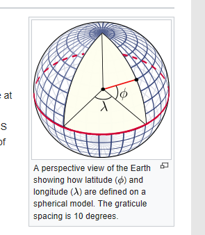
The World Geodetic System (WGS) is a standard for use in cartography, geodesy, and navigation including GPS. It comprises a standard coordinate system for the Earth, a standard spheroidal reference surface (the datum or reference ellipsoid) for raw altitude data, and a gravitational equipotential surface (the geoid) that defines the nominal sea level.
...
The WGS 84 datum surface is an oblate spheroid with equatorial radius a = 6378137 m at the equator and flattening f = 1/298.257223563.[6] The polar semi-minor axis b then equals a × (1 − f) = 6356752.3142 m.[6]
Wikipedia
...
The WGS 84 datum surface is an oblate spheroid with equatorial radius a = 6378137 m at the equator and flattening f = 1/298.257223563.[6] The polar semi-minor axis b then equals a × (1 − f) = 6356752.3142 m.[6]
Wikipedia
Wednesday, May 9, 2018
UsingGMaps
To use Google Maps in an app, one needs to get an access code
from Google. Below, I am using that of W3 Schools. Three settings have to be
adjusted initially: latitude, longitude and zoom level. Below, to
view St-Jean-sur-Richelieu and Montreal Island on opening.
* * *
Still thinking about 'elementFromPoint'. It picks up the topmost element.
* * *
Before thinking about a Google Maps app, one does need to be clear about
how the original works. It centers the map on a set of Longitude and Latitude
coordinates. Wanting to pursue, with Saint-Jean sur Richelieu as the center of a my map,
I found that Wikipedia gave me coordinates expressed in degrees and minutes, rather than
the decimal form I needed. Found a site to do the conversion, cited below.
https://www.fcc.gov/media/radio/dms-decimal
So my town, at zoom level 15 specified by the code on W3 Schools, looks like this.
Let's run a scenario, wherein I am a bemused tourist sitting at McDonald's in need
of services. The map needs to center on the restaurant. On the conventional map, I can
find the coordinates if I type the address: it will show up in the URL. I can also right click
for a 'what's there', and GMaps will show it to me. This is useful if to know if I am planning
a private app.
https://www.online-tech-tips.com/computer-tips/find-longitude-latitude/
The public App for St-Jean:
Getting the coordinates:
In the W3 tutorial, I can show many maps at once, and see combine the info. The
'hybrid' view is interesting for driving.
Here, a bird's eye of McDonald's. On the private app, this is possible because - holding down control - I will move in and out with the zoom.
But like with the public app, if I zoom from a mouse over, I can easily end up in the middle of nowhere.
https://www.w3schools.com/graphics/tryit.asp?filename=trymap_basic_many
from Google. Below, I am using that of W3 Schools. Three settings have to be
adjusted initially: latitude, longitude and zoom level. Below, to
view St-Jean-sur-Richelieu and Montreal Island on opening.
* * *
Still thinking about 'elementFromPoint'. It picks up the topmost element.
* * *
Before thinking about a Google Maps app, one does need to be clear about
how the original works. It centers the map on a set of Longitude and Latitude
coordinates. Wanting to pursue, with Saint-Jean sur Richelieu as the center of a my map,
I found that Wikipedia gave me coordinates expressed in degrees and minutes, rather than
the decimal form I needed. Found a site to do the conversion, cited below.
https://www.fcc.gov/media/radio/dms-decimal
So my town, at zoom level 15 specified by the code on W3 Schools, looks like this.
Let's run a scenario, wherein I am a bemused tourist sitting at McDonald's in need
of services. The map needs to center on the restaurant. On the conventional map, I can
find the coordinates if I type the address: it will show up in the URL. I can also right click
for a 'what's there', and GMaps will show it to me. This is useful if to know if I am planning
a private app.
https://www.online-tech-tips.com/computer-tips/find-longitude-latitude/
The public App for St-Jean:
Getting the coordinates:
In the W3 tutorial, I can show many maps at once, and see combine the info. The
'hybrid' view is interesting for driving.
Here, a bird's eye of McDonald's. On the private app, this is possible because - holding down control - I will move in and out with the zoom.
But like with the public app, if I zoom from a mouse over, I can easily end up in the middle of nowhere.
Tuesday, May 8, 2018
Expensive
France seems to be buckling up for tough economic times ahead: expensive oil,
expensive money.
https://www.nouvelobs.com/monde/20180508.OBS6351/accord-nucleaire-iranien-les-10-consequences-de-la-folle-decision-de-trump.html
https://www.nouvelobs.com/edito/20180507.OBS6283/macron-et-si-la-fete-etait-finie.html
expensive money.
https://www.nouvelobs.com/edito/20180507.OBS6283/macron-et-si-la-fete-etait-finie.html
Monday, May 7, 2018
Monday Morn
Playing with JQuery's animate function. Might work on the final
tableau of the puzzle.
Tested both id and class 'draggable' on the image and neither works. Have
to assume I am using a JQuery plug-in on one of my versions...
To the credit of Javascript.info, they do have some code to develop an accept
drop functionality, which I could usefully learn to use. (If this headache ever
recedes👩).
* * *
Are you a fullstack?
At least, it's not a joke about running a full stack!!
* * *
Below, a view of the elementFromPoint() method, which identifies the
element by the fact that the coordinates cited are those of the element.
MY PIC will respond to the function, because the points cited fall within
the element. (And I found those by installing a clientX mouse tracker on the
page). Now can I create a drop-able div...
* * *
Looks like this approach is not suitable for someone in North America, since
it is no longer maintained on the Microsoft browser.
tableau of the puzzle.
Tested both id and class 'draggable' on the image and neither works. Have
to assume I am using a JQuery plug-in on one of my versions...
To the credit of Javascript.info, they do have some code to develop an accept
drop functionality, which I could usefully learn to use. (If this headache ever
recedes👩).
* * *
Are you a fullstack?
At least, it's not a joke about running a full stack!!
* * *
Below, a view of the elementFromPoint() method, which identifies the
element by the fact that the coordinates cited are those of the element.
MY PIC will respond to the function, because the points cited fall within
the element. (And I found those by installing a clientX mouse tracker on the
page). Now can I create a drop-able div...
* * *
Looks like this approach is not suitable for someone in North America, since
it is no longer maintained on the Microsoft browser.
Sunday, May 6, 2018
Subscribe to:
Posts (Atom)