Doxa
Thursday, May 10, 2018
Interesting
The
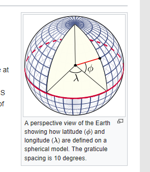
World Geodetic System
(
WGS
) is a standard for use in
cartography
,
geodesy
, and
navigation
including
GPS
. It comprises a standard
coordinate system
for the
Earth
, a standard
spheroidal
reference surface (the
datum
or
reference ellipsoid
) for raw
altitude
data, and a
gravitational
equipotential surface
(the
geoid
) that defines the
nominal sea level
.
...
The WGS 84 datum surface is an
oblate spheroid
with equatorial radius
a
=
6
378
137
m at the
equator
and
flattening
f
= 1/
298.257
223
563
.
[6]
The polar semi-minor axis
b
then equals
a
× (1 −
f
) =
6
356
752.3142
m.
[6]
Wikipedia
No comments:
Post a Comment
Newer Post
Older Post
Home
Subscribe to:
Post Comments (Atom)

No comments:
Post a Comment